Instrument
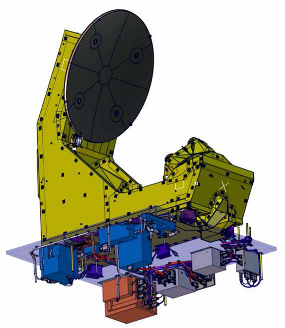
- SWIM is a real-aperture radar (RAR) system at Ku-band (13.575 GHz), pointing at incidence angles between 0 and 10° (multi-incidence beams) with a beam scanning and in azimuth (0-360°).
- The nadir looking observations have requirements similar to standard altimeter missions in terms of range resolution, accuracy of significant wave height, and wind speed. The observations at nadir will be used in a way similar to other radar-altimeters (ERS-2, TOPEX-POSEIDON, JASON) for estimating wind speed and significant wave height.
- The off-nadir looking observations are defined to fulfil the objective of measuring the directional ocean wave spectra, and statistics of wave slopes. The off-nadir observations will be used to (a) estimate the spectral properties of the wave field by measuring the modulation of the radar cross-section within the footprint, with a high horizontal resolution (effective resolution ˜ 35 m) (b) estimate the profile of the radar cross-section with incidence (0-10°) and in accordance with the azimuth.
The geometry of observations is shown in the figure on the right. For an orbit altitude of 500 km, the footprint will be about 18 km x 18 km. This footprint will sweep a pseudo-circle with a diameter ranging from 18 to 90 km for incidence angles ranging from 2 to 10°. The surface pattern completed by the instrument for all the incidence angles is shown in Figure 2 for successive scans over 360° in azimuth, and for a satellite motion of 7 km/s.
The validity of the principle to derive the spectra of ocean waves from this real-aperture radar has been demonstrated several times using airborne systems developed at NASA (ROWS system) and in France (KuROS radar at CNRS-LATMOS, France).
Recent studies supported by the French Space Agency CNES and performed at Thales Alenia Space and CNRS-LATMOS have proved the feasibility of the proposed space-borne system (Hauser et al, 2001).
The retrieval of the directional spectrum of surface waves is based on the analysis of the modulations of the radar backscatter due to the tilt of the backscattering surface by the long waves (several tens to several hundred metres in wavelength).
In each observation direction, the modulations of the backscatter coefficient due to long waves are analyzed within the footprint, using a spectral analysis. The modulation spectrum is then related to the spectrum of the waves through a linear relationship. The azimuth scanning provides the complete information (directional spectrum), with however a 180° ambiguity in the propagation direction. Signal processing inspired from the SAR wave mode data processing of ENVISAT (cross-spectra)—see Engen and Johnsen, 1995, Bao et Alpers, 1998 —is proposed in order to remove the 180° ambiguity in direction.
The combination of several incidence angles is proposed first to optimize the spatial scale for the retrieval of the wave spectral properties. Usually, the directional information obtained by combining different incidence angles is representative of an area of 70 km x 70 km.
The multi-incidence concept is also designed to derive properties of the statistics of the sea surface slope (mean square slope, shape of the slope probability density function) and tentatively to estimate wind direction and wind speed. Over land surface, it will be used to separate the respective role of vegetation and soil moisture in the radar signal, whereas over ice surface, it will be used to better characterize the ice sheet.
For all these applications, an analysis of the fall-off with incidence of the normalized radar cross-section (NRCS) will be applied.
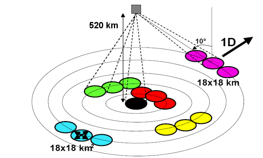
Geometry of observations of SWIM

Surface patterns described by the SWIM antenna beams for an orbit altitude of 500 km, an satellite ground track speed of 7 km/s, and a rotation of the beams of 6 rotations per minute. The horizontal axis is the along-track distance and the vertical axis.